West Sioux Falls
Here's a marker found near the Elmwood Park ball diamonds in northwest Sioux Falls (Google Maps link.)
I remember going to West Sioux Hardware as a kid, and marvelling at the animals on display there. There seemed to be an endless string of rooms filled with the trophies; enough to keep a kid more than busy for however long it'd take for Dad to take care of business up front.
Other than the old hardware store, and the fact that I was once employed near the West Sioux area, I don't feel much of a connection with the area. Mom & Dad would talk about the days of going to the West Sioux Pavilion (I think that's what it was called) for dances and whatnot, but these days it's just another neighborhood. But I guess every neighborhood has some history behind it.

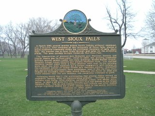
West Sioux FallsIn March 1889, several months before South Dakota achieved statehood, Evan B. Meredith, first president of the University of Sioux Falls, platted a future residential community within the northwest boundary of early Sioux Falls. His purpose was to raise funds through land sales for the struggling school. The area quickly became known as West Sioux Falls.
The intersection of present day Burnside and Madison Streets and Lincoln Avenue was its focal point. Prior to 1900, the growing community included several modest homes and farm buildings, Beuhlah Baptist Church, Meredith School, Edson Grocery and wooded Meredith Park. The earliest residents hauled water from a small shallow well next to the grocery store which was soon replaced by a larger community well located at the northwest corner of Bailey Street and Garfield Avenue. Industrial and agricultural businesses were established west of the Big Sioux River. Despite the economic hard times which followed the Panic of 1893 and which existed into the new century, the community continued to grow.
Following World War I, the surrounding flat grassy fields served as makeshift landing sites for barnstorming aviators. Thrilling air shows included stunt flying, wing-walking, parachute jumps, and aerial acrobatics. In 1920 a 40 acre West Soo Amusement Park was opened in the former Meredith Park. The up-and-coming Lawrence Welk Orchestra and other musical groups regularly played for public dances held in the dance pavilion.
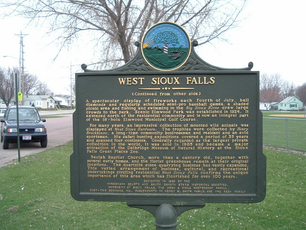
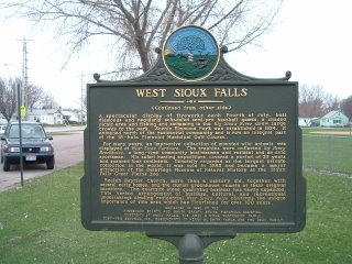
A spectacular display of fireworks each Fourth of July, ball diamonds and regularly scheduled semi-pro baseball games, a shaded picnic area and fishing and swimming in the Big Sioux River drew large crowds to the park. Scenic Elmwood Park was established in 1924. It extended north of the residential community and is now an integral part of the 18-hole Elmwood Municipal Golf Course.
For many years, an impressive collection of mounted wild animals was displayed at West Sioux Hardware. The trophies were collected by Henry Brockhouse, a long-time community businessman and resident and an avid sportsman. His safari hunting expeditions covered a period of 35 years and spanned four continents. Generally regarded as the largest private collection in the world, it was sold in 1985 and became a major attraction at the Delbridge Museum of Natural History at the Sioux Falls Great Plains Zoo.
Beuhlah Baptist Church, more than a century old, together with several early homes, and the florist greenhouse remain at their original locations. The quartzite stone quarrying business has vastly expanded. This varied arrangement of business, cultural, and recreational undertakings circling residential West Sioux Falls confirms the unique importance of this area which has flourished for over 100 years.Dedicated in 1996 by the
Minnehaha County and South Dakota State Historical Societies,
University of Sioux Falls, the Amby & Viola Westendorf Family, Dust-Tex Services, Inc., Descendants of Henry W. Smith Family, and the Feay Family.
I remember going to West Sioux Hardware as a kid, and marvelling at the animals on display there. There seemed to be an endless string of rooms filled with the trophies; enough to keep a kid more than busy for however long it'd take for Dad to take care of business up front.
Other than the old hardware store, and the fact that I was once employed near the West Sioux area, I don't feel much of a connection with the area. Mom & Dad would talk about the days of going to the West Sioux Pavilion (I think that's what it was called) for dances and whatnot, but these days it's just another neighborhood. But I guess every neighborhood has some history behind it.
posted by davintosh at 6:42 PM
![]()

2 Comments:
Any idea what this bridge was used for? It's located in Elmwood Park and is parallel to Harlem. http://twitpic.com/1xx8b1
I'm not really sure exactly what it was used for, but I'm guessing that it was originally a bridge over the Big Sioux, or one of its tributaries. The path the river follows now isn't its original or natural path. The Army Corps of Engineers built the diversion channel back in the early '60's to help control flooding in the city, and in the process pretty much erased the original riverbed. From what I understand it used to wind all over the place through the western part of the city; the oxbows that still exist between 41st & 49th & 57th near Sertoma Park are all remnants of the original riverbed. And the Riverview Heights area, between 18th & 22nd Streets just east of Kiwanis Ave. was named so because at the time it was developed, you really could view the river from the hill.
I thought it a little ironic that you mentioned that bridge, because although I've lived in Sioux Falls nearly all of my life, I don't remember seeing until this spring.
Thanks for commenting; this blog has been up for several years, and I think yours is the first. Congratulations! And welcome to Sioux Falls!
Post a Comment
<< Home