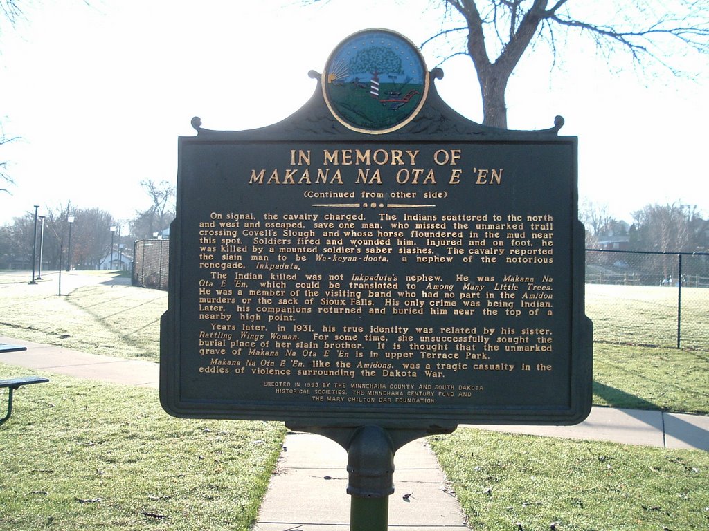
In Memory of Makana Na Ota E 'En
Here's a marker marker near an old haunt of mine; Terrace Park Swimming Pool and Covell Lake.

Wow. The policy of "shoot first, ask questions later" really sucks. I wonder how different things would be in this area — this country — if we had taken the time to not only talk but communicate, and live up to our agreements.
It's probably a good thing that this marker wasn't put up until 1993, otherwise I, along with every other North-End kid, would've been digging holes all over Terrace Park looking for this guy's bones.
And yet another reference to the Amidon murders. Was it the fact that Joseph Amidon was a judge that caused people to react the way they did? Or maybe it was the way Joseph and William were killed; from movies and TV we get the impression that that sort of Indian-on-white attack was common. Perhaps it wasn't at all common, and the fact that the Amidons were attacked without provocation caused the people of Sioux Falls to strike back in this way.

In Memory of Makana Na Ota E 'EnEnnraged over the broken promises of the white man, the Santee Sioux, led by Chief Little Crow, launched the "War of the Outbreak" - or "Dakota War" -- in August, 1882, along the Minnesota River. Little Crow ordered White Lodge's band, camped near Lake Benton, Minnesota, to drive out the settlers along the Dakota border and in the Big Sioux River valley.
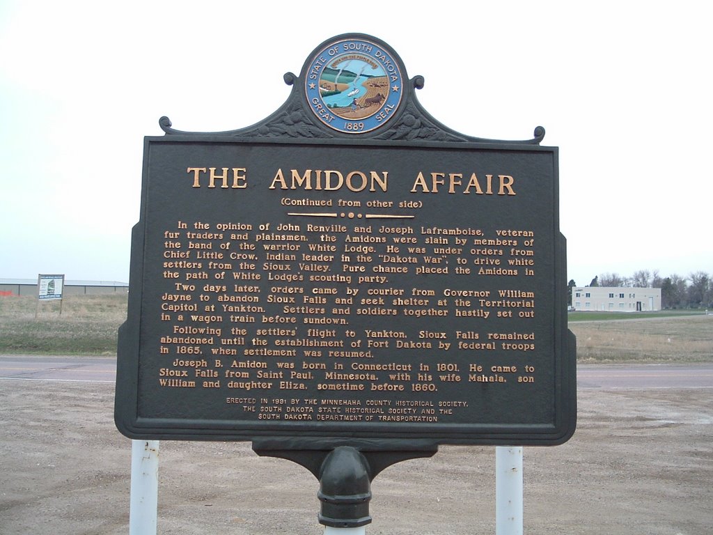
On August 25, 1862, Judge Joseph B. Amidon and his son, William, were slain by Indians while making hay near the north edge of Sioux Falls. Territorial Governor William Jayne ordered evacuation of the settlement. Following the Yankton Stage Trail, the settlers fled to Yankton, led by a detachment of Dakota Cavalry.
In November, a scouting party under Captain Nelson Miner returned to Sioux Falls. Included in the party were a number of civilians who had been residents of Sioux Falls before its evacuation. Many of the civilians had chached goods which they how wished to recover. Using caution, the scouting party camped overnight on the south side of the Big Sioux River near the present location of the Yankton Trail Bridge. They continued at dawn and when "they reached the top of the south hills" (present day 14th Street between Dakota and Minnesota Avenues) they not only discovered the settlement burned and in ruin, but also sighted a band of Indians near the Falls.
On signal, the cavalry charged. The Indians scattered to the north and west and escaped, save one man, who missed the unmarked trail crossing Covell's Slough and whose horse floundered in the mud near this spot. Soldiers fired and wounded him. Injured and on foot, he was killed by a mounted soldier's saber slashes. The cavalry reported the slain man to be Wa-keyan-doota, a nephew of the notorious renegade, Inkpaduta.
The Indian killed was not Inkpaduta's nephew. He was Makana Na Ota E 'En, which could be translated to Among Many Little Trees. He was a member of the visiting band who had no part in the Amidon murders or the sack of Sioux Falls. His only crime was being an Indian. Later his companions returned and buried him near the top of a nearby high point.
Years later, in 1931, his true identity was related by his sister, Rattling Wings Woman. For some time, she unsuccessfully sought the burial place of her slain brother. It is thought that the unmarked grave of Makana Na Ota E 'En is in upper Terrace Park.
Makana Na Ota E 'En, like the Amidons, was a tragic casualty in the eddies of violence surrounding the Dakota War.Erected in 1993 by the Minnehaha County and South Dakota
Historical Societies, the Minnehaha Century Fund and
the Mary Chilton DAR Foundation
Wow. The policy of "shoot first, ask questions later" really sucks. I wonder how different things would be in this area — this country — if we had taken the time to not only talk but communicate, and live up to our agreements.
It's probably a good thing that this marker wasn't put up until 1993, otherwise I, along with every other North-End kid, would've been digging holes all over Terrace Park looking for this guy's bones.
And yet another reference to the Amidon murders. Was it the fact that Joseph Amidon was a judge that caused people to react the way they did? Or maybe it was the way Joseph and William were killed; from movies and TV we get the impression that that sort of Indian-on-white attack was common. Perhaps it wasn't at all common, and the fact that the Amidons were attacked without provocation caused the people of Sioux Falls to strike back in this way.
posted by davintosh at 8:09 PM
0 comments
![]()


