Monday, April 17, 2006

Frederick Manfred's "Siouxland"

I've never read any of Manfred's works, and know little of him. A Google search yields a lot of information on the man, and here is what the bronze plaque at the north end of Falls Park has to say about him:


This spot is near the center of an area called "Siouxland," so named by writer Frederick F. Manfred (1912-1994). Manfred established a distinct identity for this region, the drainage basin of the Big Sioux River. It includes parts of Iowa, Minnesota, Nebraska and South Dakota. Manfred was born on an Iowa farm and christened Frederick Feike Feikema VII. He chose to live in Siouxland after years in politics and journalism in Minneapolis. His home was at thte south edge of Blue Mound near Luverne, Minnesota, on the side of what was once an ancient mountain range that stood 30,000 feet above sea level. From his writing tepee atop his house, Manfred could see far across the landscape of Siouxland.

For Manfred, Siouxland contained no rigid state boundary lines. Rather, he envisioned it as an area with distinct social, cultural, and economic values that made its people unique. His writings often reflect his farm upbringing and echo the voices of the farmers, who as settlers, began learning the hard, enduring lessons of the land over a century ago. The voices of native Sioux Indians are heard as well in several of his books, including Lord Grizzly (1954), Conquering Horse (1959), Scarlet Plume (1964), and The Manly-Hearted Woman (1975). Manfred concurred in the Indian beliefs that all people are one with the land and that the land and all life are connected and "wakan," or "holy." Thus Siouxland was "holy land."


Many of Manfred's novels are set in Siouxland. This is the Year (1947) deals with a man's treatment of farmland southeast of Sioux Falls. Conquering Horse is set in Minnehaha County when it was tribal land. It is the story of No Name, a young Yankton Sioux brave, who camps by the "river of the Double Bend" (the Big Sioux River), takes hsi ritual bath at "Falling Water" (the Falls of the Big Sioux), makes his vision quest, and returns victorious , as "Conquering Horse," chief of the Yanktons.

Frederick Manfred illustrated his love of Siouxland and his belief in its uniqueness and importance in his fictional place names and in his personal involvement. He taught at the University of South Dakota (1968-1984) and was a consultant in the Humanities at Augustana College in Sioux Falls (1984-1994). In both his writings and in his life, Siouxland becomes "holy land."
DEDICATED IN 2000 by the MINNEHAHA COUNTY HISTORICAL SOCIETY
AND THE CITY OF SIOUX FALLS

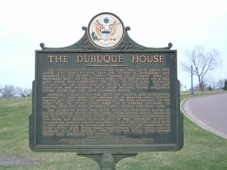
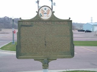
The Dubuque House

I know nothing more about this site than what is on the plaque. The plaque is located in Falls Park, near the Horse Barn Art Museum (Google Maps link.) Here is what it says:
The Dubuque House, Sioux Falls' first hotel, was built about 350 yards due wewst of this spot by Wilmot w. Brookings and members of the Western Town Company of Dubuque, Iowa, in September 1857. In the previous year, they had staked out a 320 acre claim and established the town of Sioux Falls, Minnesota Territory, on the west side of the Big Sioux River. The new town-site was northwest of a large wooded island, originally called Brookings but later renamed Seney.

Although Dubuque House was built for visitors and prospective settlers, it may have also served as a meeting hall, freight station and post office. It appears in the field notes and on the first map of Sioux Falls made by a federal surveyor in Augus, 1859, the only building shown within the town-site.

The primitive hotel was built of rough undressed blocks of Sioux Quartzite, found in the stone outcroppings which surround the Falls of the Big Sioux River. No photographs or sketches of the hotel are known to exist, but it was probably a rough rectangular-shaped structure featuring a single open room with a loft above and a cellar below. Sleeping accomodations were crude, with cloth sack mattresses filled with prairie grasses on rough wooden cots or on the floor, with animal skins and blankets for covers.


Since the settlers had a steam-driven saw mill, we can assume that the roof was probably made of rough boards and light wooden poles covered with thatch and dirt, much like settlers' cabins. Windows were small and covered with cloth or skins. Oil lamps provided any interior lighting. There probably was not an innkeeper in residence; whether visitors paid for sleeping space is uncertain. But the existence of the Dubuque House enabled the town promoters to assure the world that the new city did indeed have a new hotel!

With the rest of the town, Dubuque House was abandoned in the Dakota War of 1862 and probably burned by the Santee Sioux. When Fort Dakota, D.T., was established in 1865 at what is now the northeast corner of Phillips Avenue and Eighth Street, the Sioux Falls town-site was included within the boundaries of the 70 square-mile military reservation surrounding the Fort. Not until Fort Dakota was closed in 1869 was the military reservation reopened for civilian settlement. The remains of the Dubuque House were razed and the stones were probably used to begin the construction of teh Stevenson Hotel near the intersection of North Main Avenue and Falls Park Drive. Although that hotel's walls were erected, the building was never completed. However, in 1874, stone from the unfinished Stevenson Hotel was used nearby for the construction of the city's first brewery.

DEDICATED IN 1997 BY THE MINNEHAHA COUNTY AND SOUTH DAKOTA STATE HISTORICAL SOCIETIES, MINNEHAHA CENTURY FUND AND BLAKE LAW OFFICES


Thursday, April 13, 2006

The Queen Bee Mill


The Queen Bee Mill, a goliath among mills in early Dakota Territory, once stood tall and proud here on the bank of the Big Sioux River. A large quartzite deposit on the site was used to build an impressive seven-story flour mill.

The building of the mill was the result of the work of many people, led by R. F. Pettigrew of Sioux Falls. Pettigrew, one of the leading political and business figures of the city, secured money to construct the mill from a group of investors led by George I. Seney, a New York City banker. It has long been believed, though unproven, that Pettigrew tricked Seney into putting up the money. According to that legend, Pettigrew arranged for the construction of a dam upstream on the Big Sioux River, and as the men approached the river, on signal, the dam was broken. The resulting flow of water over the falls was sufficient to convince Seney that the mill should be built.

In August 1879, construction began on an 81-acre site that was purchased for $38,000. After two years of building and fitting, the Queen Bee was ready, at a cost of nearly half a million dollars. It was 104 feet tall, 80 feet wide, and 100 feet long. Water from the Big Sioux River was diverted into a large turbine which generated 800 horsepower. The Queen Bee Mill, known as "the most ambitious attempt ever made to use waterpower west of the Mississippi River," was capable of producing 1,200 barrels of flour daily. One hundred men worked within and around the mill complex.


The very river which was to provide the source of power to operate the mill also threatened to destroy it before the first wheat was ground. On April 20, 1881, spring run-off from melted snow and ice overflowed the banks o fthe Big Sioux River, creating the worst flood in the recorded history of Sioux Falls. The mill took a pounding, but, as it was built of "a stone that is unsurpassed by any building material that exists in the world," it withstood the onslaught of the raging river with damage limited to mill offices.

The Queen Bee Mill began grinding Dakota spring wheat October 25, 1881. By early 1883, owing $97,000 to creditors, the mill was bankrupt. It failed because of insufficient waterpower, the scarcity of high grade wheat and the inability to pay dividends to its investors. The mill complex changed ownership several times, then shut down forever shortly after the end of World War I when it became a storage facility.

On January 30, 1956, the Queen died a fiery death. Portions of the walls of the mill, built of "a stone with which it is fitting that
we should find heaven paved," remain to remind future generations of the economic struggles of the past.

DEDICATED IN 1995 BY THE MINNEHAHA COUNTY AND SOUTH DAKOTA STATE HISTORICAL SOCIETIES, CITIBANK, MIDCONTINENT AND MARY CHILTON DAR FOUNDATIONS.


The story of the Queen Bee Mill is fairly remarkable, and it's fitting that it should be the first in my listing of Sioux Falls Historic Sites. I remember my Mom telling me this story, long before the monument was erected in front of the ruins of the mill (so it must be true!) As a kid my buddies & I would play in & around the ruins -- no iron fence to keep you out back then, but there were plenty of rocks and dirt and holes to hide in. I'm sure those holes were home to a few hobos from time to time, but we'd keep our distance.

Actually, I don't doubt that the legend of the scam to get the mill built is true. First is the sheer size of the mill; knowing the usual flow of the Big Sioux, and that it barely rates as a stream during the late summer months, I doubt that there was ever enough water to keep a monster like that running. Then there is the fact that it was built to mill flour. That usually requires wheat, and growing up I don't remember much wheat being grown in the area at all. Lots of corn & soybeans, but no wheat. I asked my Dad about that once, and he said the soil in this area wasn't right for wheat. Sure, I grew up almost a hundred years after the mill was built, but I don't think that the soil would've been much more favorable to growing wheat back then.

You can get a bird's-eye view of the Mill's ruins here, thanks to Google Maps. Scroll around a bit to get a view of the Falls, the spillway, which is just north of the Mill. I've always thought it interesting that the river actually makes a full loop around the city, with the diversion channel and spillway closing the circle; our own moat!

Tuesday, April 11, 2006

Sioux Falls Historic Sites

Pretty creative title, eh? As that title suggests, this blog is all about the many historical sites in the marvelous municipality known as Sioux Falls, South Dakota. Scattered here & there throughout the city are spiffy little bronze historical markers that have been placed by one historical society or another, marking the location of some significant event or landmark of the city's history.

Recently, I was curious as to whether there might exist a central listing of all of the markers in the area, and went looking online for it. Surprisingly there is nothing of the sort to be found. I even contacted the webmaster for the South Dakota State Historical Society, who forwarded my message to the Research Room Administrator for SDSHS, and was told that there was none.

Being the kind of guy that doesn't like to leave needs unfilled, I thought I'd take a shot at putting together a site that includes photos of the historical markers, the transcribed text on those markers, photos of the landmarks (if they still exist) and whatever I can recall or dig up concerning those sites. Today is April 11, 2006, and I took the first photos last night, just getting started. Please don't consider this blog a complete listing of the markers; there are hundreds of these markers, I am doing this in my already sparse spare time, so as I see it this will always be a work in progress.

I've been a resident of Sioux Falls for pretty much my whole life, as were my parents and one set of my grandparents, and over the years have learned a fair bit of the history of the city. If you're reading something on this site and you think it's incorrect or if you have something to add, please post a response. All it takes is a Blogspot account, and signing up with Blogspot is about as easy as it gets.

So, here goes nothin!