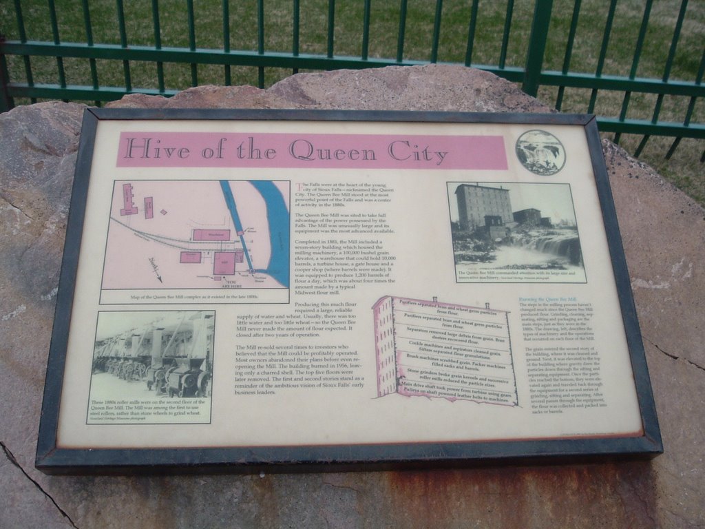
The Queen Bee Mill

The Queen Bee Mill, a goliath among mills in early Dakota Territory, once stood tall and proud here on the bank of the Big Sioux River. A large quartzite deposit on the site was used to build an impressive seven-story flour mill.
The building of the mill was the result of the work of many people, led by R. F. Pettigrew of Sioux Falls. Pettigrew, one of the leading political and business figures of the city, secured money to construct the mill from a group of investors led by George I. Seney, a New York City banker. It has long been believed, though unproven, that Pettigrew tricked Seney into putting up the money. According to that legend, Pettigrew arranged for the construction of a dam upstream on the Big Sioux River, and as the men approached the river, on signal, the dam was broken. The resulting flow of water over the falls was sufficient to convince Seney that the mill should be built.
In August 1879, construction began on an 81-acre site that was purchased for $38,000. After two years of building and fitting, the Queen Bee was ready, at a cost of nearly half a million dollars. It was 104 feet tall, 80 feet wide, and 100 feet long. Water from the Big Sioux River was diverted into a large turbine which generated 800 horsepower. The Queen Bee Mill, known as "the most ambitious attempt ever made to use waterpower west of the Mississippi River," was capable of producing 1,200 barrels of flour daily. One hundred men worked within and around the mill complex.

The very river which was to provide the source of power to operate the mill also threatened to destroy it before the first wheat was ground. On April 20, 1881, spring run-off from melted snow and ice overflowed the banks o fthe Big Sioux River, creating the worst flood in the recorded history of Sioux Falls. The mill took a pounding, but, as it was built of "a stone that is unsurpassed by any building material that exists in the world," it withstood the onslaught of the raging river with damage limited to mill offices.
The Queen Bee Mill began grinding Dakota spring wheat October 25, 1881. By early 1883, owing $97,000 to creditors, the mill was bankrupt. It failed because of insufficient waterpower, the scarcity of high grade wheat and the inability to pay dividends to its investors. The mill complex changed ownership several times, then shut down forever shortly after the end of World War I when it became a storage facility.
On January 30, 1956, the Queen died a fiery death. Portions of the walls of the mill, built of "a stone with which it is fitting that
we should find heaven paved," remain to remind future generations of the economic struggles of the past.DEDICATED IN 1995 BY THE MINNEHAHA COUNTY AND SOUTH DAKOTA STATE HISTORICAL SOCIETIES, CITIBANK, MIDCONTINENT AND MARY CHILTON DAR FOUNDATIONS.

The story of the Queen Bee Mill is fairly remarkable, and it's fitting that it should be the first in my listing of Sioux Falls Historic Sites. I remember my Mom telling me this story, long before the monument was erected in front of the ruins of the mill (so it must be true!) As a kid my buddies & I would play in & around the ruins -- no iron fence to keep you out back then, but there were plenty of rocks and dirt and holes to hide in. I'm sure those holes were home to a few hobos from time to time, but we'd keep our distance.
Actually, I don't doubt that the legend of the scam to get the mill built is true. First is the sheer size of the mill; knowing the usual flow of the Big Sioux, and that it barely rates as a stream during the late summer months, I doubt that there was ever enough water to keep a monster like that running. Then there is the fact that it was built to mill flour. That usually requires wheat, and growing up I don't remember much wheat being grown in the area at all. Lots of corn & soybeans, but no wheat. I asked my Dad about that once, and he said the soil in this area wasn't right for wheat. Sure, I grew up almost a hundred years after the mill was built, but I don't think that the soil would've been much more favorable to growing wheat back then.
You can get a bird's-eye view of the Mill's ruins here, thanks to Google Maps. Scroll around a bit to get a view of the Falls, the spillway, which is just north of the Mill. I've always thought it interesting that the river actually makes a full loop around the city, with the diversion channel and spillway closing the circle; our own moat!
posted by davintosh at 9:12 AM
![]()

0 Comments:
Post a Comment
<< Home